| Mount St. Helens |
Mount St. Helens, located in southwestern Washington about 50 miles northeast of Portland, Oregon, is one of several
lofty volcanic peaks that dominate the Cascade Range of the Pacific Northwest; the range extends from Mount
Garibaldi in British Columbia, Canada, to Lassen Peak in northern California. Geologists call Mount St. Helens a
composite volcano (or stratovolcano), a term for steepsided, often symmetrical cones constructed of alternating layers
of lava flows, ash, and other volcanic debris. Composite volcanoes tend to erupt explosively and pose considerable
danger to nearby life and property. In contrast, the gently sloping shield volcanoes, such as those in Hawaii, typically
erupt nonexplosively, producing fluid lavas that can flow great distances from the active vents. Although Hawaiian-type
eruptions may destroy property, they rarely cause death or injury. Before 1980, snow-capped, gracefully symmetrical
Mount St. Helens was known as the "Fujiyama of America." Mount St. Helens, other active Cascade volcanoes, and
those of Alaska form the North American segment of the circum-Pacific "Ring of Fire," a notorious zone that produces
frequent, often destructive, earthquake and volcanic activity.
Some Indians of the Pacific Northwest variously called Mount St. Helens "Louwala-Clough," or "smoking mountain." The
modern name, Mount St. Helens, was given to the volcanic peak in 1792 by Captain George Vancouver of the British
Royal Navy, a seafarer and explorer. He named it in honor of a fellow countryman, Alleyne Fitzherbert, who held the
title Baron St. Helens and who was at the time the British Ambassador to Spain. Vancouver also named three other
volcanoes in the Cascades--Mounts Baker, Hood, and Rainier--for British naval officers.
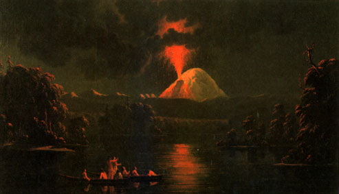
Indians on the Cowlitz River watching an eruption of Mount St. Helens, as painted by Canadian artist Paul Kane
following a visit to the volcano in 1847 (Photograph courtesy of the Royal Ontario Museum).
The local Indians and early settlers in the then sparsely populated region witnessed the occasional violent outbursts of
Mount St. Helens. The volcano was particularly restless in the mid-19th century, when it was intermittently active for at
least a 26-year span from 1831 to 1857. Some scientists suspect that Mount St. Helens also was active sporadically
during the three decades before 1831, including a major explosive eruption in 1800. Although minor steam explosions
may have occurred in 1898, 1903, and 1921, the mountain gave little or no evidence of being a volcanic hazard for
more than a century after 1857. Consequently, the majority of 20th-century residents and visitors thought of Mount St.
Helens not as a menace, but as a serene, beautiful mountain playground teeming with wildlife and available for leisure
activities throughout the year. At the base of the volcano's northern flank, Spirit Lake, with its clear, refreshing water
and wooded shores, was especially popular as a recreational area for hiking, camping, fishing, swimming and boating.
The tranquility of the Mount St. Helens region was shattered in the spring of 1980, however, when the volcano stirred
from its long repose, shook, swelled, and exploded back to life. The local people rediscovered that they had an active
volcano in their midst, and millions of people in North America were reminded that the active--and potentially
dangerous--volcanoes of the United States are not restricted to Alaska and Hawaii.
Previous Eruptive History
The story of Mount St. Helens is woven from geologic evidence gathered during studies that began with Lieutenant
Charles Wilkes' U.S. Exploring Expedition in 1841. Many geologists have studied Mount St. Helens, but the work of
Dwight R. Crandell, Donal R. Mullineaux, Clifford A. Hopson, and their associates, who began their studies in the late
1950's, has particularly advanced knowledge of Mount St. Helens. Their systematic studies of the volcanic deposits,
laboratory investigations of rock and ash samples, and radiocarbon (carbon-l4) dating of plant remains buried in or
beneath the ash layers and other volcanic products enabled them to reconstruct a remarkably complete record of the
prehistoric eruptive behavior of Mount St. Helens.
Ancestral Mount St. Helens began to grow before the last major glaciation of the Ice Age had ended about 10,000
years ago. The oldest ash deposits were erupted at least 40,000 years ago onto an eroded surface of still older
volcanic and sedimentary rocks. Intermittent volcanism continued after the glaciers disappeared, and nine main pulses
of pre-1980 volcanic activity have been recognized. These periods lasted from about 5,000 years to less than 100
years each and were separated by dormant intervals of about 15,000 years to only 200 years. A forerunner of Spirit
Lake was born about 3,500 years ago, or possibly earlier, when eruption debris formed a natural dam across the
valley of the North Fork of the Toutle River. The most recent of the pre-1980 eruptive periods began about A.D. 1800
with an explosive eruption, followed by several additional minor explosions and extrusions of lava, and ended with the
formation of the Goat Rocks lava dome by 1857.
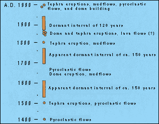
The post-A.D. 1400 segment of the 50,000-year eruptive history of Mount St. Helens (after USGS Bulletin 1383-C).
Mount St. Helens is the youngest of the major Cascade volcanoes, in the sense that its visible cone was entirely
formed during the past 2,200 years, well after the melting of the last of the Ice Age glaciers about 10,000 years ago.
Mount St. Helens' smooth, symmetrical slopes are little affected by erosion as compared with its older, more glacially
scarred neighbors--Mount Rainier and Mount Adams in Washington, and Mount Hood in Oregon. As geologic studies
progressed and the eruptive history of Mount St. Helens became better known, scientists became increasingly
concerned about possible renewed eruptions. The late William T. Pecora, a former Director of the USGS, was quoted
in a May 10, 1968, newspaper article in the Christian Science Monitor as being "especially worried about snow-covered
Mt. St. Helens."
On the basis of its youth and its high frequency of eruptions over the past 4,000 years, Crandell, Mullineaux, and their
colleague Meyer Rubin published in February 1975 that Mount St. Helens was the one volcano in the conterminous
United States most likely to reawaken and to erupt "perhaps before the end of this century." This prophetic conclusion
was followed in 1978 by a more detailed report, in which Crandell and Mullineaux elaborated their earlier conclusion
and analyzed, with maps and scenarios, the kinds, magnitudes, and areal extents of potential volcanic hazards that
might be expected from future eruptions of Mount St. Helens. Collectively, these two publications contain one of the
most accurate forecasts of a violent geologic event.
Reawakening and Initial Activity
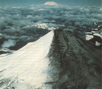
A view to the north of the "two-tone" mountain--an appearance produced by prevailing easterly winds during the initial
activity of Mount St. Helens. Mount Rainier is visible in background (Photograph by C. Dan Miller).
A magnitude 4.2 (Richter Scale) earthquake on March 20, 1980, at 3:47 p.m. Pacific Standard Time (PST), preceded
by several much smaller earthquakes beginning as early as March 16, was the first substantial indication of Mount St.
Helens' awakening from its 123-year sleep. Earthquake activity increased during the following week, gradually at first
and then rather dramatically at about noon on March 25. The number of earthquakes recorded daily reached peak
levels in the next 2 days, during which 174 shocks with magnitudes greater than 2.6 were recorded. Many hundreds of
smaller earthquakes accompanied these larger events, the largest of which were felt by people living close to the
volcano. Aerial observations of Mount St. Helens during the week of seismic buildup revealed small
earthquake-induced avalanches of snow and ice, but no sign of an eruption.
With a thunderous explosion, or possibly two nearly simultaneous ones, widely heard in the region at about 12:36 p.m.
PST on March 27, Mount St. Helens began to spew ash and steam, marking the first significant eruption in the
conterminous United States since that of Lassen Peak, California, from 1914 to 1917. The crown of the ash column
rose to about 6,000 feet above the volcano. The initial explosions formed a 250-foot-wide crater within the larger,
preexisting snow- and ice-filled summit crater, and new fractures broke across the summit area.
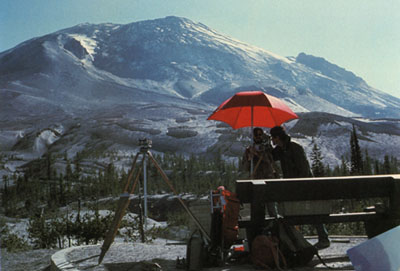
View of the "bulge" on the north face of Mount St. Helens, from a measurement site about 2 miles to the northeast
(Photograph by Peter Lipman). The drawing above the photograph illustrates, in a highy exaggerated fashion, the
nearly horizontal movement--about 85 feet in 20 days--of one of the measured points on the "bulge."
- NEXT PAGE -
lofty volcanic peaks that dominate the Cascade Range of the Pacific Northwest; the range extends from Mount
Garibaldi in British Columbia, Canada, to Lassen Peak in northern California. Geologists call Mount St. Helens a
composite volcano (or stratovolcano), a term for steepsided, often symmetrical cones constructed of alternating layers
of lava flows, ash, and other volcanic debris. Composite volcanoes tend to erupt explosively and pose considerable
danger to nearby life and property. In contrast, the gently sloping shield volcanoes, such as those in Hawaii, typically
erupt nonexplosively, producing fluid lavas that can flow great distances from the active vents. Although Hawaiian-type
eruptions may destroy property, they rarely cause death or injury. Before 1980, snow-capped, gracefully symmetrical
Mount St. Helens was known as the "Fujiyama of America." Mount St. Helens, other active Cascade volcanoes, and
those of Alaska form the North American segment of the circum-Pacific "Ring of Fire," a notorious zone that produces
frequent, often destructive, earthquake and volcanic activity.
Some Indians of the Pacific Northwest variously called Mount St. Helens "Louwala-Clough," or "smoking mountain." The
modern name, Mount St. Helens, was given to the volcanic peak in 1792 by Captain George Vancouver of the British
Royal Navy, a seafarer and explorer. He named it in honor of a fellow countryman, Alleyne Fitzherbert, who held the
title Baron St. Helens and who was at the time the British Ambassador to Spain. Vancouver also named three other
volcanoes in the Cascades--Mounts Baker, Hood, and Rainier--for British naval officers.
Indians on the Cowlitz River watching an eruption of Mount St. Helens, as painted by Canadian artist Paul Kane
following a visit to the volcano in 1847 (Photograph courtesy of the Royal Ontario Museum).
The local Indians and early settlers in the then sparsely populated region witnessed the occasional violent outbursts of
Mount St. Helens. The volcano was particularly restless in the mid-19th century, when it was intermittently active for at
least a 26-year span from 1831 to 1857. Some scientists suspect that Mount St. Helens also was active sporadically
during the three decades before 1831, including a major explosive eruption in 1800. Although minor steam explosions
may have occurred in 1898, 1903, and 1921, the mountain gave little or no evidence of being a volcanic hazard for
more than a century after 1857. Consequently, the majority of 20th-century residents and visitors thought of Mount St.
Helens not as a menace, but as a serene, beautiful mountain playground teeming with wildlife and available for leisure
activities throughout the year. At the base of the volcano's northern flank, Spirit Lake, with its clear, refreshing water
and wooded shores, was especially popular as a recreational area for hiking, camping, fishing, swimming and boating.
The tranquility of the Mount St. Helens region was shattered in the spring of 1980, however, when the volcano stirred
from its long repose, shook, swelled, and exploded back to life. The local people rediscovered that they had an active
volcano in their midst, and millions of people in North America were reminded that the active--and potentially
dangerous--volcanoes of the United States are not restricted to Alaska and Hawaii.
Previous Eruptive History
The story of Mount St. Helens is woven from geologic evidence gathered during studies that began with Lieutenant
Charles Wilkes' U.S. Exploring Expedition in 1841. Many geologists have studied Mount St. Helens, but the work of
Dwight R. Crandell, Donal R. Mullineaux, Clifford A. Hopson, and their associates, who began their studies in the late
1950's, has particularly advanced knowledge of Mount St. Helens. Their systematic studies of the volcanic deposits,
laboratory investigations of rock and ash samples, and radiocarbon (carbon-l4) dating of plant remains buried in or
beneath the ash layers and other volcanic products enabled them to reconstruct a remarkably complete record of the
prehistoric eruptive behavior of Mount St. Helens.
Ancestral Mount St. Helens began to grow before the last major glaciation of the Ice Age had ended about 10,000
years ago. The oldest ash deposits were erupted at least 40,000 years ago onto an eroded surface of still older
volcanic and sedimentary rocks. Intermittent volcanism continued after the glaciers disappeared, and nine main pulses
of pre-1980 volcanic activity have been recognized. These periods lasted from about 5,000 years to less than 100
years each and were separated by dormant intervals of about 15,000 years to only 200 years. A forerunner of Spirit
Lake was born about 3,500 years ago, or possibly earlier, when eruption debris formed a natural dam across the
valley of the North Fork of the Toutle River. The most recent of the pre-1980 eruptive periods began about A.D. 1800
with an explosive eruption, followed by several additional minor explosions and extrusions of lava, and ended with the
formation of the Goat Rocks lava dome by 1857.
The post-A.D. 1400 segment of the 50,000-year eruptive history of Mount St. Helens (after USGS Bulletin 1383-C).
Mount St. Helens is the youngest of the major Cascade volcanoes, in the sense that its visible cone was entirely
formed during the past 2,200 years, well after the melting of the last of the Ice Age glaciers about 10,000 years ago.
Mount St. Helens' smooth, symmetrical slopes are little affected by erosion as compared with its older, more glacially
scarred neighbors--Mount Rainier and Mount Adams in Washington, and Mount Hood in Oregon. As geologic studies
progressed and the eruptive history of Mount St. Helens became better known, scientists became increasingly
concerned about possible renewed eruptions. The late William T. Pecora, a former Director of the USGS, was quoted
in a May 10, 1968, newspaper article in the Christian Science Monitor as being "especially worried about snow-covered
Mt. St. Helens."
On the basis of its youth and its high frequency of eruptions over the past 4,000 years, Crandell, Mullineaux, and their
colleague Meyer Rubin published in February 1975 that Mount St. Helens was the one volcano in the conterminous
United States most likely to reawaken and to erupt "perhaps before the end of this century." This prophetic conclusion
was followed in 1978 by a more detailed report, in which Crandell and Mullineaux elaborated their earlier conclusion
and analyzed, with maps and scenarios, the kinds, magnitudes, and areal extents of potential volcanic hazards that
might be expected from future eruptions of Mount St. Helens. Collectively, these two publications contain one of the
most accurate forecasts of a violent geologic event.
Reawakening and Initial Activity
A view to the north of the "two-tone" mountain--an appearance produced by prevailing easterly winds during the initial
activity of Mount St. Helens. Mount Rainier is visible in background (Photograph by C. Dan Miller).
A magnitude 4.2 (Richter Scale) earthquake on March 20, 1980, at 3:47 p.m. Pacific Standard Time (PST), preceded
by several much smaller earthquakes beginning as early as March 16, was the first substantial indication of Mount St.
Helens' awakening from its 123-year sleep. Earthquake activity increased during the following week, gradually at first
and then rather dramatically at about noon on March 25. The number of earthquakes recorded daily reached peak
levels in the next 2 days, during which 174 shocks with magnitudes greater than 2.6 were recorded. Many hundreds of
smaller earthquakes accompanied these larger events, the largest of which were felt by people living close to the
volcano. Aerial observations of Mount St. Helens during the week of seismic buildup revealed small
earthquake-induced avalanches of snow and ice, but no sign of an eruption.
With a thunderous explosion, or possibly two nearly simultaneous ones, widely heard in the region at about 12:36 p.m.
PST on March 27, Mount St. Helens began to spew ash and steam, marking the first significant eruption in the
conterminous United States since that of Lassen Peak, California, from 1914 to 1917. The crown of the ash column
rose to about 6,000 feet above the volcano. The initial explosions formed a 250-foot-wide crater within the larger,
preexisting snow- and ice-filled summit crater, and new fractures broke across the summit area.
View of the "bulge" on the north face of Mount St. Helens, from a measurement site about 2 miles to the northeast
(Photograph by Peter Lipman). The drawing above the photograph illustrates, in a highy exaggerated fashion, the
nearly horizontal movement--about 85 feet in 20 days--of one of the measured points on the "bulge."
- NEXT PAGE -
FUN FACTS ABOUT Mount St. Helens